f
faseeh1020

FaseehT

@faseeh1020

GIS and Remote Sensing Expert, Turning Spatial Data into Insights

Pakistan
Anglais, Ourdou, Punjabi
Certaines informations sont présentées en anglais.
À propos de moi
specialising in GIS, Remote Sensing, and Spatial Analysis. I create professional GIS maps using ArcGIS, and Google Earth Engine. My services include LULC classification, NDVI analysis, urban expansion studies, and detailed geographic reports. I have practical experience analysing Gujranwala’s urban growth, ensuring accurate and high-quality results. I deliver clear, well-structured maps and reports for research, planning, and decision-making. Client satisfaction, timely delivery, and clear communication are my priorities. Feel free to contact me before placing an order.... Plus d’infos

Compétences

f
faseeh1020
FaseehT
hors ligne • 
Temps de réponse moyen de 1 heure

Voir mes services

Consulting en analyse de données
I will gis mapping and spatial analysis services at 15 USD
Programmation et Tech
I will do gis mapping, remote sensing, spatial analysis, ndvi, lst, uhi

Portfolio

Expérience professionnelle

University of Gujrat

Indépendant • 5 yrs 2 mos

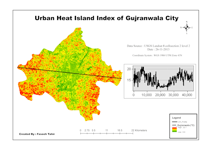
Urban Expansion Analysis (Gujranwala)

Oct 2023 - Present2 yrs 7 mos

Conducted urban expansion analysis using GIS and remote sensing techniques Used ArcGIS / Google Earth Engine for spatial data processing Analyzed land use changes from 2000–2026 Created maps and spatial reports for research purposes

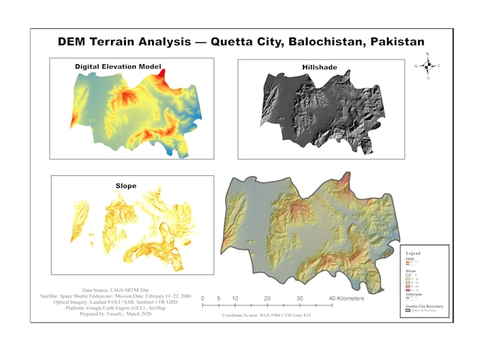
GIS & Mapping Projects

Oct 2023 - Present2 yrs 7 mos

Created GIS maps using ArcGIS Performed NDVI and LULC analysis Developed spatial analysis reports and visualizations Worked on academic and personal GIS projects