Parcourir les catégories
Explorer
Fiverr Pro
Français
$
USD
Level 1


Traduction automatique
Je suis ingénieur géospatial (Master) avec plus de 15 ans d’expérience dans la création de modèles numériques d’altitude, cartes de contours, solutions SIG, LiDAR et levés topographiques. J’aide les ingénieurs, consultants, chercheurs et aménageurs à transformer des données d’altitude brutes en modèles de surface précis et prêts à la décision.
Ce service inclut :
Livrables principaux
Services complémentaires
Je livre dans le format de fichier et la résolution adaptés à votre logiciel. Indiquez-moi simplement votre programme cible et je dimensionnerai les fichiers en conséquence.
Outils que j’utilise : ArcGIS Pro, QGIS, Google Earth, Global Mapper, Pix4D, Metashape, AutoCAD Civil 3D
Fait confiance à des clients réguliers dans le monde entier.
Envoyez-moi votre source de données et la zone du projet (adresse, coordonnées ou épingle Google Maps), et je confirmerai le périmètre, les livrables et le délai avant votre commande.
GIS Mapping, Drone Surveying, CAD Site Plans, 3D Modeling and Animations
Level 1
Langues
Traduction automatique
Traduction automatique
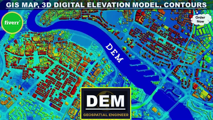
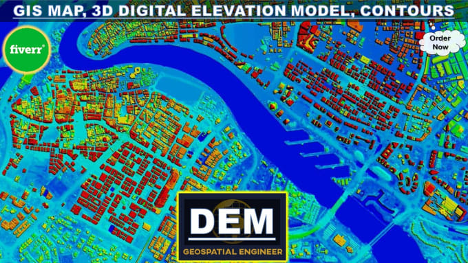
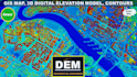
Qu'est-ce qu'un modèle numérique d'élévation (DEM) ?
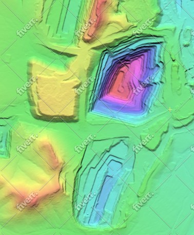
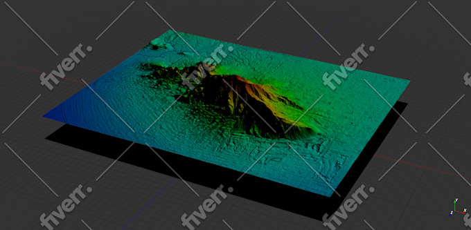
Un modèle numérique d'élévation (DEM) est une représentation infographique 3D de données d'élévation pour représenter le terrain. DEM est une couche SIG raster avec des grilles raster de la surface de la Terre référencées par rapport à la référence verticale (altitude zéro).
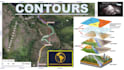
Que sont les courbes de niveau et les cartes topographiques ?
En termes simples, les courbes de niveau marquent des points d’égale altitude sur une carte. La topographie est l'étude des caractéristiques géographiques d'un paysage. Une carte comportant des courbes de niveau est appelée carte topographique. Essentiellement, les cartes topographiques représentent le paysage tridimensionnel de la Terre dans l'espace 2D d'une carte.
De quelles données avez-vous besoin pour créer un DEM et une carte de contour ?
Pour créer un DEM et une carte de contour, j'ai généralement besoin de données d'élévation provenant de sources telles que les topo topographiques ou les levés de terrain (GNSS, DGPS, Station totale, scanner laser, LiDAR), l'imagerie stéréo photogrammétrique (images satellite, photographies aériennes), SAR, Ensembles de données radar ou feuilles topographiques.
Pouvez-vous personnaliser les intervalles de contour et les spécifications de la carte en fonction de mes besoins ?
Absolument! Je comprends que différents projets peuvent avoir des exigences uniques. Que vous ayez besoin d'intervalles de contours spécifiques, d'étendues de carte, de systèmes de coordonnées ou d'autres spécifications, je peux adapter les livrables pour répondre exactement à vos besoins.
Quels types de projets peuvent bénéficier de vos services ?
Mes services sont idéaux pour un large éventail de projets, notamment l'aménagement du territoire, la conception technique, la modélisation des bassins versants, la planification du site, l'analyse climatique, etc. Que vous soyez une société d'ingénierie ou un consultant en environnement, je peux vous aider avec vos besoins en cartographie de contour SIG et en DEM.
Quelles sont les applications étendues des modèles numériques d’élévation ?
- Systèmes d'information géographique / Cartographie SIG - Arpentage et contours topographiques - Visualisation 3D - Génie civil - Hydrologie / Modélisation hydrologique - Modèles et cartographie des inondations - Autoroutes / Ingénierie de l'environnement / des ressources en eau - Télécommunications et services publics
Quel logiciel utilisez-vous pour développer des DEM et des cartes de contour ?
Je me spécialise dans l'utilisation d'ArcGIS Pro, un logiciel SIG professionnel, pour développer des DEM et des cartes de contour de haute qualité. ArcGIS Pro offre des fonctionnalités avancées d'analyse et de visualisation du terrain, garantissant des résultats précis et détaillés.
Quel est le délai d’exécution habituel pour livrer le produit final ?
Le délai d'exécution peut varier en fonction de la complexité et de l'ampleur du projet. Après avoir discuté de vos besoins, je vous fournirai un délai de livraison estimé. Rassurez-vous, je m'efforce de fournir des résultats de haute qualité dans les meilleurs délais afin de respecter les délais de votre projet.
Proposez-vous des révisions si je ne suis pas satisfait des livrables initiaux ?
Oui, la satisfaction du client est primordiale pour moi. Je propose des révisions pour garantir que les livrables finaux répondent à vos attentes et aux exigences du projet.
| (15) | ||
| (1) | ||
| (0) | ||
| (0) | ||
| (0) |
bleblanc03

États-Unis
Great to work with. Delivered nice assets for my project. I would not hesitate to reach out again if/when I need more work at this level.
400 $US-600 $US
Prix
3 semaines
Durée
jebjeb2000
États-Unis
I needed a model of a mountain for architectural rendering. Geospatial provided a highly detailed file that was actually far too large for my program to handle. Geospatial followed up with several options of smaller size, and I was able to use the edits. They were communicative in adjusting the parameters to fit what I needed. Thank you!
100 $US-200 $US
Prix
2 semaines
Durée

Réponse du freelance
ricmed372
Client récurrent
États-Unis
Thank you. I appreciate the work
100 $US-200 $US
Prix
5 jours
Durée

jasonwarner845
Client récurrent

Costa Rica
This is my third order with Geospatial. Always high quality, timely, and visually appealing.
Jusqu’à 50 $US
Prix
1 jour
Durée
jasonwarner845
Client récurrent
Costa Rica
This is my second project with Geospatial Engr. I found them after an underwhelming experience with another provider. Very pleased with the technical capabilities and professional way they presented the data. When the need arises, I would be happy to work with Geospatial again.
100 $US-200 $US
Prix
8 jours
Durée
| (15) | ||
| (1) | ||
| (0) | ||
| (0) | ||
| (0) |
bleblanc03
États-Unis
Great to work with. Delivered nice assets for my project. I would not hesitate to reach out again if/when I need more work at this level.
400 $US-600 $US
Prix
3 semaines
Durée
jebjeb2000
États-Unis
I needed a model of a mountain for architectural rendering. Geospatial provided a highly detailed file that was actually far too large for my program to handle. Geospatial followed up with several options of smaller size, and I was able to use the edits. They were communicative in adjusting the parameters to fit what I needed. Thank you!
100 $US-200 $US
Prix
2 semaines
Durée
Réponse du freelance
ricmed372
Client récurrent
États-Unis
Thank you. I appreciate the work
100 $US-200 $US
Prix
5 jours
Durée
jasonwarner845
Client récurrent
Costa Rica
This is my third order with Geospatial. Always high quality, timely, and visually appealing.
Jusqu’à 50 $US
Prix
1 jour
Durée
jasonwarner845
Client récurrent
Costa Rica
This is my second project with Geospatial Engr. I found them after an underwhelming experience with another provider. Very pleased with the technical capabilities and professional way they presented the data. When the need arises, I would be happy to work with Geospatial again.
100 $US-200 $US
Prix
8 jours
Durée