Parcourir les catégories
Explorer
Fiverr Pro
Français
$
USD

GIS Specialist, GeoAI Specialist, Data Analyst
Compétences
Voir mes services

GIS Specilaist
Geo • Freelance
Apr 2019 - Present • 7 yrs 3 mos
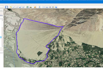
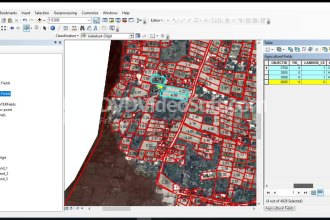
• Monitor GIS mapping activities. • Monitor the GIS Associate work and Performance Evaluation of GIS Associate. • Ensure that end users are provided with relevant GIS based maps and reports. • Assist in capacity development activities for Agriculture officials in the area of GIS. • Design and organize training courses for department’s technical staff on GIS and RS. • Promote research on different relevant thematic areas with integration of GIS/RS to fill the data gaps to support effective decision making. • Collection of data related to Agriculture and livestock to development of Geo-Database from the automated Farmer facilitation System (FFS). • Acquisition of Data from Fisheries Department for construction of GIS Maps, Database. • Report presentation in National and International workshops. • Present the result of GIS activities in Departmental and Research forum. • Concept Paper and PC-I preparation and paper Publications and presentation related to Agriculture, Livestock & Fisheries Department in national and international conferences and workshops. • Complex satellite GIS Data analysis from open source data (Landsat, Sentinel, MODIS and SPOT data)
| (15) | ||
| (2) | ||
| (2) | ||
| (0) | ||
| (0) |

noah_redford

États-Unis
Difficult to communicate with. Didn’t seem willing to go above and beyond, but he did respond quickly.
Réponse du freelance

simonjusticehal
États-Unis
navy
États-Unis
Great seller and turned around the work super fast! Went above and beyond!
Réponse du freelance
ba6426

Allemagne
Réponse du freelance

vanessacole
Client récurrent
États-Unis