Parcourir les catégories
Explorer
Fiverr Pro
Français
$
USD

_oeeq5t.jpg)
Traduction automatique
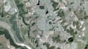
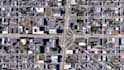
Je fournis des téléchargements d'images satellite haute résolution prêtes à être utilisées dans les logiciels SIG.
Idéal pour la cartographie, la visualisation, la planification et les rapports.
Les sources peuvent inclure Google, Bing ou d'autres plateformes d'imagerie publiques (uniquement à des fins de visualisation et de cartographie).
Smart Solutions in GIS, Excel Automation, and Web Development
Langues
Traduction automatique
Traduction automatique
Cette imagerie convient-elle pour les logiciels SIG ?
Oui. Tous les fichiers sont géoréférencés et prêts pour SIG.
Pouvez-vous faire correspondre un système de coordonnées spécifique ?
Oui, il suffit de le mentionner dans la demande.


