Parcourir les catégories
Explorer
Fiverr Pro
Français
$
USD



Traduction automatique
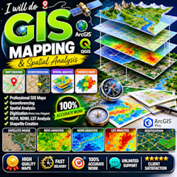
Je suis un spécialiste SIG compétent avec une expérience sur ArcGIS et QGIS. Je vais créer des cartes de haute qualité, précises et visuellement attrayantes pour vos projets, devoirs ou besoins professionnels.
Ce que je peux faire pour vous :
Cartographie SIG et cartes thématiques
Géoréférencement (cartes et images satellites)
Numérisation (points, lignes, polygones)
Analyse spatiale (NDVI, NDWI, LST)
Création et modification de shapefiles
Traitement d’images satellites
Pourquoi me choisir ?
Travail 100 % précis
Livraison rapide (disponible en 24 heures)
Mise en page professionnelle de cartes (légende, échelle, titre)
Communication amicale
Révisions illimitées (jusqu’à satisfaction)
Je me concentre sur la qualité du travail et la satisfaction du client. Votre projet sera géré de manière professionnelle avec une attention particulière aux détails.
Contactez-moi avant de passer commande pour discuter de votre projet !
Offre spéciale : les 5 premiers clients bénéficieront d’une livraison ultra rapide + réduction
Veuillez informer le freelance de toute préférence ou préoccupation concernant l'utilisation d'outils d'IA dans la réalisation et/ou la livraison de votre commande.
I will do GIS mapping, NDVI LULC analysis, shapefile and buffer analysis
Langues
Traduction automatique


