Parcourir les catégories
Explorer
Fiverr Pro
Français
$
USD

Level 1
Professional GIS and Remote Sensing Expert
Compétences
Voir mes services

Vous souhaitez travailler sur une base horaire ?
Dites à Kausar H. ce dont vous avez besoin.
20 $US
/
heureIntern
Land and Water Resource Management, IHE Delft, Netherlands
Jul 2025 - Aug 2025 • 1 mo
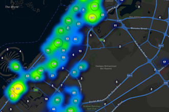
Automated Dune Slack Characterization using QGIS, conducted literature review, geospatial mapping, and reporting.
Research Associate
North South University
Sep 2022 - Sep 2024 • 2 yrs
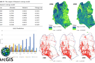
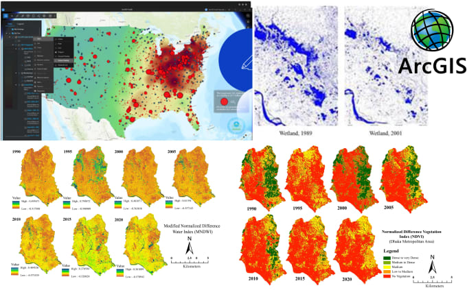
Coordinate project activities, supervise research teams for field data collection, community consultation, socio-economic survey, satellite and remote sensing analysis, and cooperate with international organizations for project completion on time.
Research Consultant
Center for Environmental and Geographic Information Services (CEGIS)
Aug 2023 - Oct 2023 • 2 mos
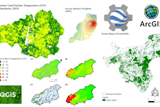
Satellite image processing, land use analysis, digitization, crop pattern detection using satellite images, and remote sensing technology
| (42) | ||
| (4) | ||
| (2) | ||
| (0) | ||
| (0) |

mairaskar

Émirats Arabes Unis
I approximate his professional communication and level of cooperation for learning new things.
fahad_alroqi

États-Unis
He did an excellent job on the project، very professional, efficient, and delivered exactly what I needed.

audreyculver
États-Unis
Was a pleasure working with Kausar H. His work exceeded my expectations and I would be happy to work with him again.

mors_magambo

Ouganda
gofram
Client récurrent

Suède