Parcourir les catégories
Explorer
Fiverr Pro
Français
$
USD



Traduction automatique
Les cartes statiques indiquent où se trouvent les choses. Les cartes interactives expliquent pourquoi elles sont importantes.
Vous cherchez à faire le lien entre une analyse GIS complexe et une interface web conviviale ? Vous avez trouvé le bon expert. Avec plus de 7 ans d’expérience en tant que ingénieur en logiciels spatiaux, je me spécialise dans la transformation de données brutes provenant de QGIS et ArcGIS Pro en applications web interactives et performantes qui facilitent la prise de décisions concrètes.
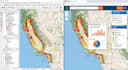
De la création du Dashboard interactif des incendies de forêt aux États-Unis à la gestion de plus de 40 projets mondiaux, je sais exactement comment gérer de grands ensembles de données spatiales tout en conservant une interface utilisateur/expérience utilisateur claire et intuitive.
Ce que j’apporte à votre projet :
Transformons vos données géospatiales en une réalité interactive.
GIS Developer, Google Earth Engine, Python Automation, ArcGIS Pro
Langues
Traduction automatique
Traduction automatique
Pouvez-vous convertir mon projet QGIS ou ArcGIS Pro en carte web ?
Oui, absolument ! Je me spécialise dans la conversion de projets GIS de bureau (.qgz, .mxd, .aprx) en cartes web interactives entièrement fonctionnelles et performantes en utilisant Leaflet, Mapbox ou OpenLayers. Toutes vos couches, symboles et attributs seront conservés.
Dois-je fournir l’hébergement pour la carte interactive ?
Cela dépend de vos besoins. Je peux fournir le code source (HTML/JS/CSS) que vous pouvez héberger sur n’importe quel serveur web (GitHub Pages, Netlify ou votre propre hébergement). Si votre projet nécessite une base de données comme PostGIS, je peux vous conseiller sur les meilleures solutions d’hébergement.
Pouvez-vous intégrer des données en temps réel comme les flux d’incendies de forêt aux États-Unis ?
Oui ! J’ai une grande expérience dans l’intégration de flux API en direct provenant de sources comme NASA FIRMS, USGS et MODIS/VIIRS. Cela permet à votre carte de se mettre à jour automatiquement avec les dernières données sur les incendies ou l’environnement.
La carte interactive sera-t-elle compatible avec les appareils mobiles ?
Certainement. Toutes les cartes web et tableaux de bord GIS que je développe sont entièrement réactifs. Elles sont optimisées pour fonctionner parfaitement sur ordinateurs, tablettes et smartphones sans perdre en fonctionnalités.


