l
luckyy_j

Janitha S.

@luckyy_j

Aspiring GIS and Geospatial Analyst

Sri Lanka
Anglais, Cinghalais
Certaines informations sont présentées en anglais.
À propos de moi
🌐 đ—Łđ—żđ—Œđ—łđ—Čđ˜€đ˜€đ—¶đ—Œđ—»đ—źđ—č 𝗚𝗜𝗩 & 𝗚đ—Čđ—Œđ˜€đ—œđ—źđ˜đ—¶đ—źđ—č đ—”đ—»đ—źđ—č𝘆𝘀𝘁 🌍 Welcome! I'm a passionate and versatile digital creator and GIS, Remote Sensing professional with years of experience delivering high-accuracy geospatial solutions worldwide. I specialize in Satellite-Derived Bathymetry and advanced GIS tasks - turning satellite data into clean, publication-ready maps, 3D visualizations, change detection, spectral indices, flood models & Python automation. You get professional GeoTIFFs, interactive results, slides & full Python code - fast, accurate, tailored to you. ... Plus d’infos

Compétences

l
luckyy_j
Janitha S.
hors ligne ‱ 
Temps de réponse moyen de 1 heure

Voir mes services

SystÚme d'information géographique (SIG)
I will do custom gis qgis arcgis mapping, spatial analysis services
SystÚme d'information géographique (SIG)
I will deliver custom python scripts for gis, remote sensing data analysis

Portfolio

Expérience professionnelle

Research Assistant (Part Time)

4 Zero Surveying and Engineering (Pvt) Ltd. ‱ Temps partiel

Oct 2024 - Nov 2025 ‱ 1 yr 1 mo

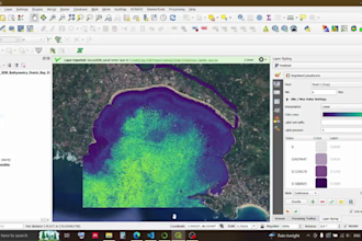
Mobile GIS Development: Designed and developed a fully functional offline GIS-powered mobile application for real-time navigation and land lot management within the Sevanagala sugarcane cultivation area. ​Geospatial Analysis: Processed multi-source datasets using QGIS and ArcGIS to produce spatial insights, maps, and technical reports for client deliverables. ​Technical Communication: Authored a series of technical articles on LinkedIn regarding advanced surveying and GIS applications to engage broader audiences. ​Project Documentation: Assisted in the preparation of project proposals and professional presentations.