Parcourir les catégories
Explorer
Fiverr Pro
Français
$
USD

I make Enterprise WebGIS and webApps using ASP dotNET 8 and React JS
Compétences
Voir mes services
Web GIS Developer
National Engineering Services Pakistan (Pvt) Limited • Temps plein
Dec 2025 - Present • 7 mos
— Developing 3-Tier Layered Architecture CRUD REST web-apps for clients using ASP.NET 8 API, JavaScript, jQuery, AJAX, SQL Server, and ArcGIS Mapping API/ArcGIS SDK Toolkit 4.3. — Designed and maintained applications using EF Core + Direct SQL execution using ADO.NET for stored procedures, ensuring robust performance on both frontend and backend. — Diagnosed and resolved API issues via Try Catch error, such as Custom exceptions, Not Found Exception, and Bad Request Exception methods to ensure smooth operation and reliability. — Contributed to the UI design, Architectural Design, Database Schema, Data Models, and API Strategy to structure the app for scalability and robust performance. — Programmed apps with OOP, Role-Based Access Control (RBAC), CQRS, asynchronous, and CORS programming paradigms for performance, scalability, and flexibility. — Delivered high-quality B2B products through a well R & D process, attention to detail, and agile project methodologies. Applied strong UI/UX design principles and worked closely with design teams to create intuitive user experiences. — Implemented scalable development strategies by adopting emerging technologies, including AI Agents, aligned with organizational goals and regulatory compliance. — Collaborated effectively across cross functional teams, demonstrating clear communication, reporting, and strong business acumen.
Geospatial Data Analyst
Farmdar (Multinational Geo AI Agri-Tech Company) • Temps plein
Jun 2022 - May 2024 • 1 yr 11 mos
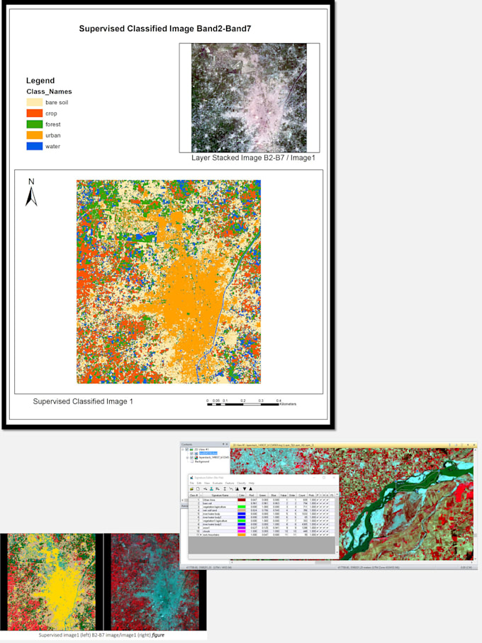
• Accomplishment in generated insightful crop-type mapping outputs and translated those outcomes into compelling stories from interpreting complex geographical datasets, enabling the stockholders to make data-driven decisions based on deep analytical facts. • Achieved the development of a Crop Mapping product, making it an outstanding high-precision B2B product by employing a data-driven geospatial approach, attention to detail and agile project management. • Attained marketing skills by interacting with customers from participating at the Pakistan Society of Sugarcane Technologies (PSST) exhibition as a Data representative individual along with other teams, ultimately expanding the client network that significantly attracted both B2B and B2C clients. • Won the Gold Medal for invaluable diligence in driving the projects forward in a fast-paced environment and sprint season, also fully utilized the leadership skills and practiced adaptability and resilience to achieve common goals. • To reduce human intervention in particular steps of the workflows, I integrated automation into manual systems such as Big Data processing or Batch Statistics using Python scripting, AWS S3 Cloud bucket, and EC2 Virtual Machines. Successfully learned automation strategies and various Python libraries for data analysis. • Utilized research and problem-solving skills to explore more better methodologies, improving the scalability of the crop mapping product, while also adapting to new technologies, and business needs and regulations. • Attained mentorship competency by providing strategic guidance to junior analysts, ensuring project requirements were understood by them to deliver effective GIS solutions. • Executed Quality Assurance and Quality Check processes to ensure the accuracy and reliability of ML model outputs and final reports. • Carried out Microsoft Excel operations incorporating Geographic data and Location Intelligence to perform different data analytics and data engineering
