Parcourir les catégories
Explorer
Fiverr Pro
Français
$
USD


I lead a skilled team of GIS specialists, bringing over 14 years of extensive expertise in GIS and Remote Sensing. My background empowers me to provide a wide range of GIS services, from routine daily tasks to complex, high-stakes projects.
Our services include:
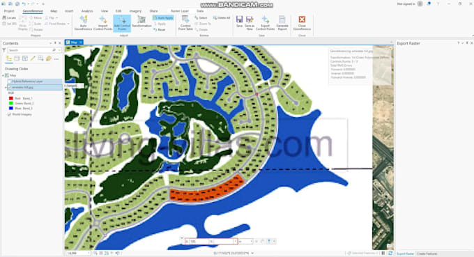
Georeferencing/Digitization of various materials such as Scanned Old Maps, Aerial Imagery, Scanned Paper Maps, Satellite Imagery, Historical Documents, Survey Plans, Utility Infrastructure Maps, Custom Drawings/Plans (including AutoCAD drawings), GIS Data from Different Coordinate Systems, Non-Geospatial Data, and more.
We undertake GIS mapping projects that necessitate the use of ArcGIS, QGIS, spatial analysis, remote sensing, WebGIS, and the creation of GIS maps.
Together, we can propel your business to new heights. Let's collaborate to develop the optimal strategy for your next endeavor.
As a dedicated GIS expert, I've collaborated with various clients. My expertise extends to various hands on skills including ArcGIS, Cartography, Data Visualization, Spatial Analysis, Digitizing, Data Visualization Analysis, Data Visualization Guidance, Geographic Information Systems, GIS Business Analysis etc.
Your GoTo Destination for Comprehensive GIS Support in Every Project
Langues