Parcourir les catégories
Explorer
Fiverr Pro
Français
$
USD


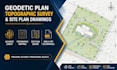
I will create accurate geodetic plan, topographic survey, contour map, and professional site plan drawings in AutoCAD Civil 3D.
Need a reliable expert for your geodetic plan, topographic survey, or site plan drawings? You're in the right place.
I help contractors, architects, developers, and land owners transform survey data into clean, accurate, and professional drawings for construction, planning, and land development projects.
Services I Offer
Why Choose This Gig?
Software & Tools
Whether you need a geodetic plan for approvals or a topographic survey for engineering design, I'm here to help deliver reliable and professional results.
Message me before placing your order so we can discuss your project requirements and choose the best solution for your needs.
Veuillez informer le freelance de toute préférence ou préoccupation concernant l'utilisation d'outils d'IA dans la réalisation et/ou la livraison de votre commande.
Professional Land Surveyor Boundary and Topographic Survey Expert Construction
Langues
