p
precisiongis

Ali A

@precisiongis

GIS Analyst

Pakistan
Anglais, Ourdou
Certaines informations sont présentées en anglais.
À propos de moi
I am a GIS Analyst with 1 year of freelance experience and currently working in a Civil Engneering consultancy firm . I specialize in hydrological spatial analysis, land use/land cover (LULC) mapping, and temporal analysis for change detection. I have strong experience in watershed delineation, drainage analysis, flood risk mapping, land use classification, and multi-temporal satellite imagery analysis. I focus on precision, timely delivery, and providing actionable geospatial insights to support planning and decision-making. Let’s turn your spatial data into meaningful results.... Plus d’infos

Compétences

p
precisiongis
Ali A
hors ligne • 
Temps de réponse moyen de 1 heure

Voir mes services

Consultation
I will do gis spatial analysis, lulc mapping and flood mapping

Expérience professionnelle

GIS Analyst

Designmen Consulting Engineers • Temps plein

Jun 2025 - Present11 mos

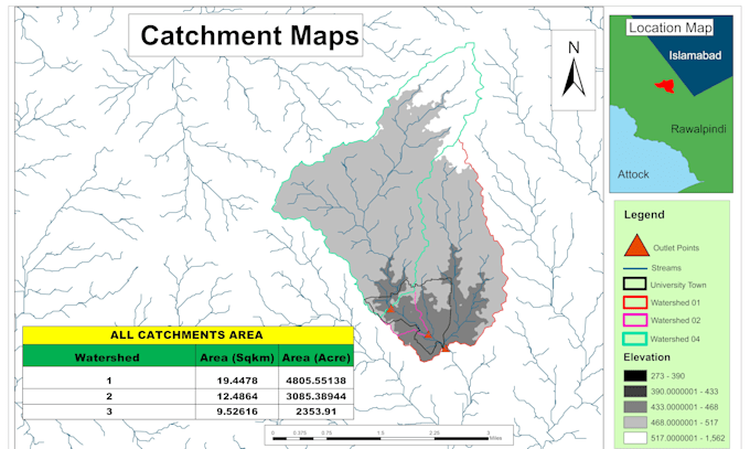
As a GIS Analyst, I am responsible for preparing Land Use/Land Cover (LULC) maps, flood hazard and floodplain maps, and performing watershed delineation for hydrological studies. I conduct detailed spatial data analysis and geospatial data processing to support planning and decision-making projects. I also develop hydrological and hydraulic models using HEC-HMS and HEC-RAS to simulate rainfall–runoff processes and flood behavior. My work involves satellite imagery analysis, map production, and the preparation of technical maps and reports, ensuring accurate, reliable, and high-quality outputs for consultancy projects.