Parcourir les catégories
Explorer
Fiverr Pro
Français
$
USD

Website Developer
Compétences
Voir mes services

Research Consultant
CGIAR • Temps plein
Nov 2024 - Present • 2 yrs
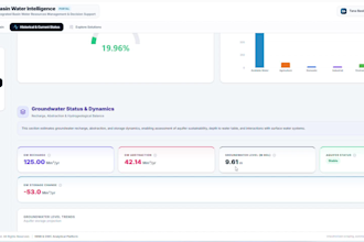
# Role & Organization Research Consultant / Assistant | International Water Management Institute (IWMI HQ) # Professional Summary Engineered end-to-end geospatial analytics workflows, interactive decision-support dashboards, and hydrologic modeling tools supporting sustainable water resource management across South Asia, the Middle East, and Latin America. Bridged complex environmental science and modern software engineering to translate satellite Earth observation data into actionable intelligence for global water policy stakeholders. # Key Highlights & Deliverables * Geospatial & Earth Observation Analytics: Automated large-scale spatial data pipelines using Google Earth Engine, Python (GDAL, Rasterio, GeoPandas), and climate datasets (ERA5, CHIRPS) to assess evapotranspiration, drought indices, and crop water requirements. * Interactive Dashboards & Decision Support: Developed and deployed modern web and desktop applications (React, Next.js, Plotly Dash, PyQt) for real-time hydrological monitoring and water accounting frameworks. * Spatial Modeling & Resource Allocation: Modeled spatial raster workflows (DEM terrain processing, flow direction algorithms, and command area delineation) for water allocation and effluent reuse prioritization. * Global Stakeholder Handover: Authored comprehensive technical documentation, containerized deployment pipelines (Docker, GCP), and led technical platform transitions for partner institutions and national agencies.
| (1) | ||
| (0) | ||
| (0) | ||
| (0) | ||
| (0) |

vishgw

Australie
Highly recommended this seller. Had a great communication through the entire process. He knew what i want exactly even though he is new to fiverr. HE did his best to manage the process and delivered it to me even before delivery date. If you are looking for something great, this is the right place
50 $US
Prix

