Parcourir les catégories
Explorer
Fiverr Pro
Français
$
USD

Krida
@timakrida
Level 1
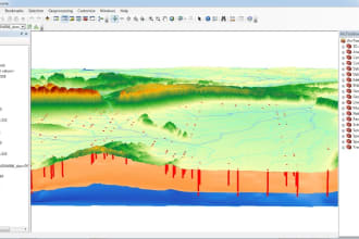
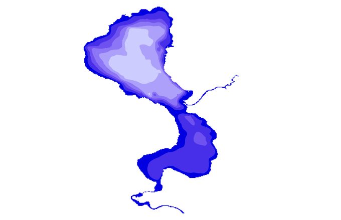
I will create professional GIS maps, bathymetric analysis
Maroc
Anglais
À propos de moi
Are you looking for a professional GIS analyst, cartographer, and geologist with over 10 years of experience? You’ve found the right expert!
I specialize in GIS mapping, spatial analysis, hydrology, and remote sensing using ArcGIS, ENVI 5.3, QGIS, and advanced geospatial tools. I have successfully delivered projects in environmental studies, geology, topography, hydrology, stormwater management, and urban planning.
My Services Include:
Cartography & Symbology –Bathymetric Data Analysis-Hydrology & Stormwater Manaent – runoff modeling, watershed delineation, drainage maps.
Topographic Mapping
Compétences

Krida
50 $US/heure
hors ligne •
Temps de réponse moyen de 1 heure
Voir mes services

Système d'information géographique (SIG)
I will create topographic contour lines

Système d'information géographique (SIG)
I will create bathymetric maps for any lakes in word
Vous souhaitez travailler sur une base horaire ?
Dites à Krida ce dont vous avez besoin.
50 $US
/
heure74 Avis
| (73) | ||
| (1) | ||
| (0) | ||
| (0) | ||
| (0) |
Détails de la notation
- Niveau de communication avec le freelance
- Qualité de la livraison
- Valeur de la livraison
1 à 5 avis sur 74
Trier par
Les plus pertinents
tianard

États-Unis
Utile?
lidamsoukouli
Client récurrent

Grèce
very satisfied, thank you Krida!
Utile?
myoung101010

États-Unis
Exceeded expectations, delivered exactly what was needed. Thank you!
Utile?
nickmikulec
Client récurrent

États-Unis
Repeat customer! He’s a Rockstar. Amazing communication, high quality work.
Utile?
lidamsoukouli
Client récurrent

Grèce
very happy with the quality of professionalism and delivery of results! I will definitely work again with Krida.
Utile?

