Parcourir les catégories
Explorer
Fiverr Pro
Français
$
USD

Dimas Gis
@danielkimaru
Mapping the Future with Precision and Innovation
Kenya
Anglais
À propos de moi
Hello!
I will make Your Remote Sensing And GIS Based Projects Using Esri’s Geographic Information System (GIS) software, I can help you visualize your data in new and different ways, unearth geographic patterns hidden in your data, and convey that information in a straightforward manner.
I offer the following services:
Classification (Supervised & Unsupervised)
Spatial Analysis
Cartography
Geo-visualization
Digital Mapping and Image Processing etc
I have worked on Remote Sensing Data Satellite Imagery.
Compétences

Dimas Gis
20 $US/heure
hors ligne •
Temps de réponse moyen de 22 heures
Voir mes services

Applications Web Full stack
I will create interactive webmap using leaflet, mapbox, open layers

Système d'information géographique (SIG)
I will do gis, interactive mapping, vector map, spatial analysis
Vous souhaitez travailler sur une base horaire ?
Dites à Dimas Gis ce dont vous avez besoin.
20 $US
/
heurePortfolio
4 Avis
| (4) | ||
| (0) | ||
| (0) | ||
| (0) | ||
| (0) |
Détails de la notation
- Niveau de communication avec le freelance
- À recommander à un ami
- Service conforme à la description
1 à 4 avis sur 4
Trier par
Les plus pertinents

kriskenbe

Belgique
Great guy to work with! Very good in communication Will think together with you.
Utile?
samialsaeed

Australie
Utile?
user82502414

États-Unis
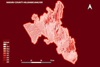
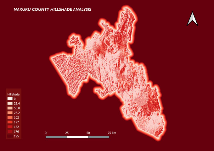
Delivery of project was timely and he understood our requirements for the locator map. Will definitely be using for future projects.
Utile?

normandan

Kenya
The seller is very polite and is understanding. He delivers his work in good time and the work is of great quality. Looking forward to work him again in future orders.
Utile?

