Je ferai des SIG, de la cartographie interactive, de la carte vectorielle, de l'analyse spatiale

D
danielkimaru
D
danielkimaru
Dimas Gis
5,0
5,0
Certaines informations ont été traduites automatiquement.

À propos de ce service

Traduction automatique

Bonjour,

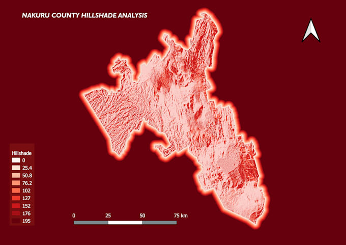
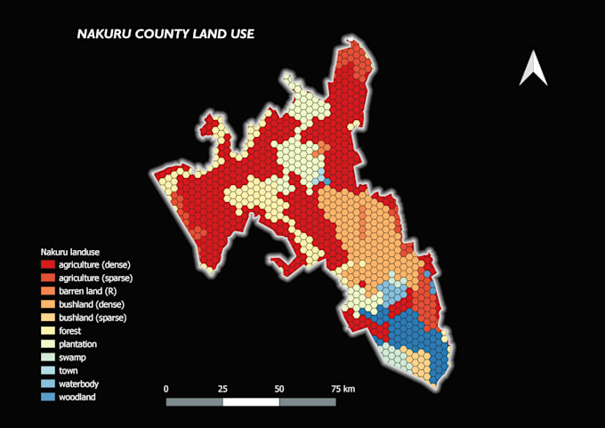
Vous cherchez un analyste GIS pour faire cartographie interactive, carte vectorielle, analyse spatiale ? Je suis là pour vous aider. J'ai une bonne expérience en GIS et analyse spatiale. Je vous fournirai des cartes prêtes à imprimer.


Services :


1. Analyse GIS incluant tout type de analyse spatiale, conversion de données, etc., dans tous les logiciels tels que ArcGIS, QGIS, Erdas et Envi


2. Web Mapping sur Google Maps, OpenLayers et Leaflet. Cela inclut aussi le WebMapping et l'analyse spatiale en ligne avec connexion aux bases de données spatiales


3. Développement de base de données spatiale en PostgresSQL avec extension spatiale PostGIS


4. HTML5, CSS, Javascript, Bootstrap.


5. Géoréférencement, numérisation, interpolation et analyse 3D, modélisation


6. leaflet Mapping, cartes web, cartes interactives


Technologies : -


  1. Logiciels GIS de bureau (ArcGIS, QGIS, Erdas, Envi)
  2. Formats de données (Shapefiles, GeoJSON, TIFF, DWG et tous autres formats de données GIS)
  3. Technologies Web GIS (leaflet, Openlayers, Mapbox, Google Earth Engine)
  4. Bases de données spatiales (PostGIS, PostgresSQL)


Découvrez Dimas Gis

Dimas Gis

Mapping the Future with Precision and Innovation

5,0(4)
  • DeKenya
  • Membre depuismai 2018
  • Temps de réponse moy.16 heures
  • Dernière commande9 mois
  • Langues

    Anglais
Hello! I will make Your Remote Sensing And GIS Based Projects Using Esri’s Geographic Information System (GIS) software, I can help you visualize your data in new and different ways, unearth geographic patterns hidden in your data, and convey that information in a straightforward manner. I offer the following services: Classification (Supervised & Unsupervised) Spatial Analysis Cartography Geo-visualization Digital Mapping and Image Processing etc I have worked on Remote Sensing Data Satellite Imagery.

Traduction automatique

Mon portfolio

Avis

2 avis concernant ce service
5,0

(2)
(0)
(0)
(0)
(0)
Détails de la notation
  • Niveau de communication avec le freelance
    5
  • À recommander à un ami
    5
  • Service conforme à la description
    5
Trier par
Les plus pertinents
  • K
    image-docs

    kriskenbe

    BE

    Belgique

    5

    Great guy to work with! Very good in communication Will think together with you.

    Utile?
    Oui
    Non
  • S

    samialsaeed

    AU

    Australie

    5

    great work

    Image d'échantillon de travail
    Utile?
    Oui
    Non